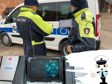
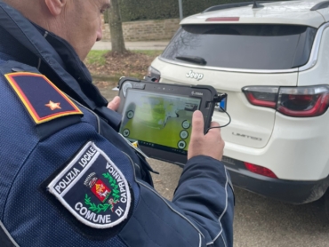
iCAM3D: the innovative survey
3D metric, planimetric survey system


YOU WILL AGREE WITH US THAT ROAD ACCIDENTS ARE DETECTED WITH PRE-HISTORICAL INSTRUMENTS
The police authorities involved in the survey and reconstruction of road accidents, in order to determine the incident, are used to proceed with a technical study that provides:
- Collection of historical data
- Collection of elements for the plan
- Localization of the collision point
- Localization and differential analysis between the different traces present on the ground (braking, incision, blood traces)
- Construction of the measuring table
- Choice of the reference point (immobility)
- Definition and management of cases where measurement monitoring is not possible
- Drafting of photographic documentation
- Damage determination

MANUAL SURVEY
In traditional mode the study is quite limited: inaccuracy and considerable waste of time and energy (“less precision” is equivalent to inaccuracy).
MANUAL DRAWING
The operators proceed, in situ, to the realization of a "manual drawing" that is usually followed by the scale reproduction (1: 100; 1: 200; etc.).


NEGATIVE ASPECTS OF THE MANUAL SURVEY

TIME
L’impiego di un lasso di TIME, non sempre quantificabile perché dipende da molti fattori, ma il più delle volte lungo. Questo ha un impatto negativo sul traffico, soprattutto quando si rende necessaria la chiusura totale e/o parziale della strada.

RISK FOR OPERATORS
Elevato RISCHIO PER LA SALUTE DEGLI OPERATORI ESPOSTI A PERICOLO DI VITA DURANTE IL RILIEVO e all'inquinamento ambientale, fattori causati dalla CONGESTIONE DEL TRAFFICO, all'origine dei c.d. incidenti secondari.

RISK FOR PEOPLE
Elevato RISCHIO PER LE PERSONE, protagoniste e non nell’incidente stradale. Studi dimostrano che il tempo incida sulla formazione delle code che sono alla base del rischio incidenti secondari al primo evento.

CONTAMINATION
The use of the measuring tape EXPOSES THE OPERATORS TO A RISK OF EXTERNAL CONTAMINATION due to the many surfaces which it comes into contact with, which are not hygienically outlineable.

Grazie all’utilizzo di iCAM3D®, sistema realizzato in Italia e tutelato da un Brevetto per Modello di Utilità n° 202017000083778, concepito per effettuare con un unico passaggio nel teatro del sinistro, un rilievo metrico / planimetrico / fotografico, e tridimensionale.
In pochi minuti si può avere una acquisizione e restituzione in misurazioni della realtà. La scena si presta ad essere navigabile ogni volta che lo necessita, senza incorrere nell’inquinamento della stessa poichè l’acquisizione è IMMODIFICABILE. iCAM3D® infatti, permette di aggiungere informazioni alla scena come acquisita ma non permette alterazioni di alcun tipo. Ecco la valenza probatoria della stessa. L’utilizzo deL nostro dispositivo permette di ricontrollare tutti gli elementi presenti (minimo graffio, incisione…) anche in un secondo momento e tutte le volte che si vuole, senza che nulla vada perso o modificato. I sensori di cui è dotato il sistema consentono, infatti, di acquisire la realtà punto per punto, in modo preciso, tempestivo e soprattutto senza richiedere elevate capacità tecniche, ma semplicemente muovendosi all’interno della scena.
Il sistema permette di caratterizzare il rilievo nella massima oggettività.
- "Point-by-point" acquisition and restitution of reality
- It allows you to re-check all the elements present on the scene EVEN AFTERWARDS, without anything being DISPERSED or MODIFIED, keeping the digital data UNCHANGED OVER TIME
- PORTABLE AND USABLE DURING MOVEMENT
- CALCULATION OF THE VOLUME OF HOLES AND SURFACES
ALL THIS CAN BE AVOIDED WITH iCam3D
in a single solution it carries out 4 different surveys

Metric

Planimetric

Photographic

3D navigation scene


SCENES DETECTION IN FEW MINUTES
iCam3D® consists of a Tablet PC, a high definition camera with depth sensors and a specific software for the technical planimetric assessment of the scene and the following planimetric reconstruction of the accident with more detail
No special skills are required

ERROR CLOSE TO 0
Thanks to the generation of 3D models, it is possible to carry out, with error close to zero, measurements of distances, angles, surfaces with objective results.

SAFETY PROTECTION OF OPERATORS
The detection of road accidents or crime scenes involve high levels of risk for operators.
The ease of use and the speed of scanning allow you to clear the scene to carry out measurements even after some time.
The use of the measuring tape exposes operators to external contamination due to the multiple surfaces which it comes into contact with, which are not hygienically profilable.

POINTS CLOUD AND GEOREFERENCING
The sensors the system is equipped with allow you to acquire 150 million points in a few minutes, while moving around the scene.. Thanks also to the use of GPS-GNSS georeferencing systems, it is possible to obtain absolute positions for the detected object.